Subtropical Storm Karen has formed, becoming the 11th named storm of the 2025 Atlantic hurricane season and raising concerns along the US East Coast.
Subtropical storms are hybrid systems, with characteristics of both tropical storms, which get energy from warm ocean waters, and extratropical storms, which draw power from temperature differences in the atmosphere.
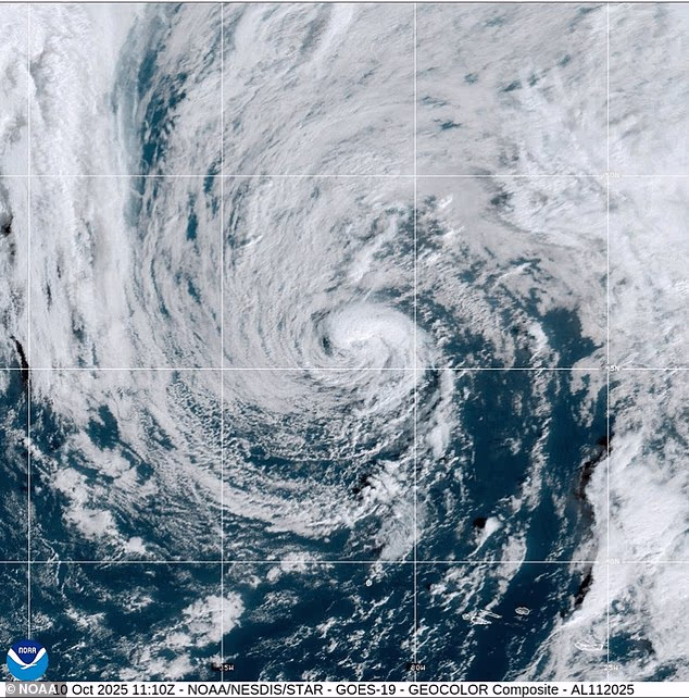
As of Friday morning, Karen remained embedded within a large upper-level low-pressure system, producing pockets of moderate thunderstorms, primarily on the eastern side of its compact circulation.
The National Hurricane Center (NHC) reported that the storm is moving northeast at about 9mph and is expected to accelerate as it interacts with an approaching deep-layer trough from the west.
Karen is traveling over cooler waters, with sea surface temperatures below 68°F, but frigid air aloft has allowed it to maintain some organized convection.
However, meteorologists warn that environmental and oceanic conditions are becoming increasingly hostile, and the storm’s days as a compact subtropical system are likely numbered.
Karen comes as more than ten million Americans, from Georgia to Massachusetts, have been advised to prepare for heavy rain, pounding waves and major flooding due to a nor’easter developing off the East Coast.
According to AccuWeather, the storm is rated a 1, meaning it could produce hurricane-like conditions along parts of the coast.
Subtropical Storm Karen has formed in the northern Atlantic, but meteorologists believe it will be short-lived as it moves closer to the US

However, a nor’easter is forecast to develop off the East Coast this weekend and last for several days with significant coastal flooding, heavy rain and strong winds
Forecast models have shown that Karen will likely lose its thunderstorms by early Saturday. After that, the storm is expected to break apart and be absorbed by a nearby weather front.
Karen does not pose much danger to land, but its development shows how subtropical storms interact with ocean temperatures and upper-atmosphere conditions in the North Atlantic.
AccuWeather meteorologists, however, are monitoring the system along the East Coast, warning that it could evolve into a named tropical storm, but is likely to be ‘more akin to the powerful nor’easters.’
Chief on-air meteorologist Bernie Rayno said: ‘The storm will form just off the Georgia coast and move northward this weekend to next week.
‘As the storm drifts to the north, it will grow stronger each day.’
Should the storm’s intensity escalate, it would be named Lorenzo, which is the next name on the 2025 Atlantic list.
AccuWeather lead hurricane expert Alex DaSilva said: ‘There is a high risk this storm will be designated a subtropical (hybrid) storm, which is why we have designated this system as a tropical wind and rainstorm, and have issued an eye path map to raise early awareness ahead of potential National Hurricane Center (NHC) classification.’
Significant coastal flooding is possible from North Carolina up through New Jersey and Cape Cod.

Meteorologists warned the storm is set to unleash pounding waves along the US East Coast, causing significant flooding in some areas (file image)

The storm is set to strengthen over the weekend and linger up the East Coast into next week
Flooding is expected to develop along the North Carolina coast and the Delmarva Peninsula from Friday into Saturday, then move northward to New Jersey and the New York City area by Sunday.
Barrier islands and low-lying communities that typically flood during tropical storms or nor’easters are especially at risk.
Tides could rise one to three feet above normal, with storm surges reaching up to six feet, according to AccuWeather’s StormMax forecast.
The weather agency warned that offshore, waves will build to ten to 20 feet and could grow even higher.
Because the storm is moving slowly, coastal areas can expect several days of heavy surf and dangerous rip currents. The extended battering could cause serious erosion, damaging beaches and protective dunes.
AccuWeather senior meteorologist Dave Dombek said: ‘Along the immediate coast, winds are likely to get strong enough with this from southeastern Virginia to Delmarva, New Jersey and southeastern New York and possibly southern New England to lead to tree, power line and property damage.’
Coastal areas from North Carolina to eastern Massachusetts can expect wind gusts of 40 to 60mph, with AccuWeather’s Local StormMax gust reaching 80mph. For comparison, hurricanes have winds of 74mph or higher.
In a worst-case scenario, the storm could strengthen to hurricane force and move inland over the mid-Atlantic, creating a swath of significant storm surge, high winds and heavy rain just north of the storm’s center, meteorologists warned.
By
Source link